

Finding North and time by stars.
by tonytran2015 (Melbourne, Australia).
Click here for a full, up to date ORIGINAL ARTICLE and to help fighting the stealing of readers’ traffic.
Blog No. 008
#find North, #finding North, #direction, #time, #by stars, #sky map, #sky disk, #Mercator sky map, #declination, #right ascension,
Finding North direction and time by stars is more than just identifying the Polaris and the Little Dipper around the Northern Celestial pole or the Southern Cross around the Southern pole ! It requires knowledge in representing spherical plates on flat maps, in making star maps and in identifying stars and groups of stars.
1. THE HOLLOW CELESTIAL SPHERICAL SHELL
Stars are considered attached to a hollow Celestial spherical shell centered on the Earth, with very large radius and rotating around the rotation axis of the Earth. This spherical shell has coordinates just like the spherical surface of the Earth has. The poles of the Celestial spherical shell are the intersections of the rotation axis and the spherical shell itself. The great semi-circular arcs connecting the two poles are called the semi-circle of right ascension (R.A.) while the circles on the shell of constant distance to the poles are called the circles of declination (they all have a common axis being the Celestial axis). The arcs of right ascension and circles of declination define the position of each star on the Celestial shell.
The declination circles on the Celestial spherical shell are similar to the latitude circles on Earth while the Right Ascension arcs on the Celestial spherical shell are similar to the terrestrial longitude arcs on Earth. They are marked in hours; 360 degrees correspond to 24 hours. The 0 hr Right Ascension is the R.A. of the Sun when it crosses the Celestial Equator at Spring Equinox on March 21st of every year. On that night the 0 hr ascension arc is (invisibly) lowest while 12 hr ascension arc is highest in the sky at 24 hr.
The terms Celestial North, trailing direction, Celestial South, leading direction refer to the directions drawn on the Celestial sphere at the position of a star, respectively along the Northern direction of the RA semicircle, the trailing side of the circle of constant declination, the Southern direction of the RA semicircle and the leading side of the circle of constant declination . Non-equatorial people should note that the Leading direction of a star points to the West when it is above the Celestial axis and East when below the Celestial axis.
Stars are identified by their angular distances to known features on the Celestial sphere. Their order of brightness cannot be used as a primary mean of identification as relative brightnesses are hard to distinguish and they are often affected by weather conditions.
On the other hand, angular distances can be accurately measured using only a compass divider having two straight legs and a protractor (or a clock face; each complete revolution of the hour hand sweeps 360 degrees, other angles are derived from that). Solar and Lunar diameters can also be conveniently used as small units of 0.5 degree for angles measurement. Most hikers can readily estimate angles by the widths of their fingers and hands when their corresponding arms are fully stretched (10 degrees corresponds to a slope of 0.174, and 6 degrees to 0.10).
The upper (either Northern or Southern) Celestial pole can be found by observing star motions relative to any aiming line on the tops of two sticks planted into the ground. From the known position of the upper Celestial pole the latitude of the observer is known.
The RA line of 0 hr is the midnight meridian on the equinox night of September 23rd. The RA of any star is the time it crosses the meridian line on that night.
The stars to be used as the reference marks on the sky are Polaris (a bright star nearly right on the Celestial North pole), Vega (the second brightest star in the sky, 39 degrees from Polaris, with RA of 18 hr 36 m), Sirius (the brightest star in the sky, 106 degrees from Polaris, 74 degrees from the Southern Celestial pole, RA of 7 hr.).
Starting from Polaris and Vega it is easy to identify Altair, Deneb. Starting from Polaris, Vega and Sirius it is easy to identify Orion group of stars.
These stars can then be used to identify any other stars in the sky.
2. REPRESENTING A SPHERICAL CIRCULAR SHELL HAVING STARS BY FLAT SHEETS OF MAPS.

Figure of a sphere touching two caps and one cylinder wall. The flat sheets will be used to represent the spherical shell
We want to observe the stars and record their positions on flat sheets of paper.
We don’t want to project images of the stars from the center of the Celestial sphere onto the flat sheets touching it. Doing so will require the observer to have his eyes at predetermine distance from the flat sheet maps to keep the shapes of star constellation correct.
Six areas in the directions of the faces of a cube can reasonably represent the area of the Celestial sphere. However we will not use them here but use a tin-can representation having only the top and bottom circular caps and the optional cylinder wall. The caps will have Inversion projection and the cylinder wall will be rolled out with a Mercator projection.
3. Visibility of stars.
Any tropical star is visible nightly (either from Sunset to its setting or from its rising to Sunrise) in the tropical zone for more than 11 months each year. The visibility cycle for each star begins with the star seen rising on the Eastern horizon few minutes before Sunrise. On subsequent days, the star rises earlier and earlier, its position shifts gradually towards the West and the star remains for longer and longer duration in the night sky until one day it stays for the whole night. The star is therefore called a star of that date. After that day, the star is seen setting in the West in the night. On subsequent days, its lead on the Sun gradually increases and it sets on the West at earlier and earlier time. Near the end of the cycle, the star is visible above the Western horizon for only few minutes after Sunset. It then sets on the West. At the end of this cycle, the star is too close to the Sun to be visible in the sky.
The cycle then repeats from the beginning.
An arbitrary non-tropical star rises and sets North or South from the principal East and West directions and is visible in the sky for more (in Winter) or less (in Summer) than 12 hours.
Example:
Sirius is called the star of January 1st as it is visible for that whole night and reaches its highest elevation at that mid-night every year.
Astronomers locate stars on the Celestial sphere by their Right Ascensions, ordinary people identify them by their dates of being most useful.
As the duration of the days is nearly constant, the date and the RA of any star can be easily converted based on four principal sets of values that can be seen on the star maps. They are:
Date of maximum stay —–>> Right Ascension.
23 Sep Autumn Equinox —–>> 0 deg (0 hr) RA
21 Dec Winter Solstice ——->> 90 deg (6 hr) RA
21 Mar Spring Equinox —–>> 180 deg (12 hr) RA
21 Jun Summer Solstice —>> 270 deg (18 hr) RA.
4. TECHNIQUE OF MEASURING CELESTIAL ANGLES
Angles are main features used in star identifying. Angles can be estimated by comparing to the angle sustained by the width of one finger, or the combined width of the index and middle fingers, or the width of the closed fist on a fully stretched arm away from the aiming eye. All these rough angles can also be easily checked by aligning the stretched arm along a vertically tiled wall. As sin (10 deg) = 0.174 we have sin(6 deg)= 0.10, and any angle with a slope of 0.1 (=10%) is nearly 6 degrees.
These angles depend on the characteristic shape of an observer and should be individually determined for each observer. Easily available reference angles are:
1 Lunar diameter is slightly less than and Solar diameter is slightly more than 0.5 degree.
2x Lunar diameters are nearly 1 degree.
3x Lunar diameters are 1.5 . degrees. This may approximate the angle sustained by an index finger.
The angle sustained by a closed fist, usually of more than four finger widths may correspond to about 10 degrees. This varies with individual observers.
Large angle can be determined by aligning one index finger to the first star and neighbour middle finger to the second star. The whole hand is then kept unchanged. The angle between fingers is then placed against a clock face and read.
When angles sustained by hands are used near the zenith, the angle may increase by up to 30% due to the reduction in distance between the raised hand and the aiming eye.
Frequent checks against known reference angles are necessary. Long observation of Celestial objects may produce the “zooming in” illusion where angles seems to be much bigger than their real sizes. This phenomenon is well-known with people observing Sunsets, Sunrises, Moonsets and Moonrises.
Stars cannot be identified by only their relative brightnesses. Their brightnesses are hard to distinguish and may change with time and with Earth’s weather. Stars are positively identified by their relative brightnesses combined with their angular distances to nearby stars.
>>> When the identity of a.bright star is in doubt, its angular distances to positively identified, bright, neighbour stars will positively identify it. Frequent checks against reference known angles are necessary.
5. INVERSION PROJECTION AND THE NORTHERN HEMI-SPHERE.

Figure: Sky map of the Northern Celestial hemisphere (Inversion map, this map shows only 20 brightest stars of the sky)

Figure: Sky map (Inversion type) of the Northern Celestial 3/4-sphere showing only 20 brightest stars and some constellations.
This method let a plane touch the sphere and project all but one points on the sphere onto the plane from the point on the sphere most distant from the plane. The distance of the projection (image) of a point from the center of the projection (the contact point) is proportional to the tangent value of half the arc from the original point to the center of the projection (the contact point). This method preserves the angles of small local features so that users can readily identify the features.
This method makes meridian curves and latitude curves become orthogonal curves. Long exposure photography near to the Upper Celestial pole shows projection of latitude curves onto the film plate. The images are almost the inversion projection. Star paths form family of circles orthogonal to family of meridians.
The concentric circles on the polar map represent the declination circle on the Celestial sphere. They are placed at angles of 30, 60, 90, 120 degrees from the Celestial pole. The non-concentric circle represent the circular path of the Sun on the Celestial sphere. Solar path is called the ecliptic.
Polar maps are simple to understand. Stars move around Celestial poles 366.25/365.25 turns every 24 hours. Viewed from the Earth, they circle in the anticlockwise direction around Northern Celestial pole and they circle in the clockwise direction around Southern Celestial pole . The Sun also rotates in the same direction but with a slightly lower rate of 1 whole turn everyday. So the stars moves ahead of the Sun by 1/365.25 days. The stars and the Sun will return to their relative position after 365.25 days, that is exactly after one year.
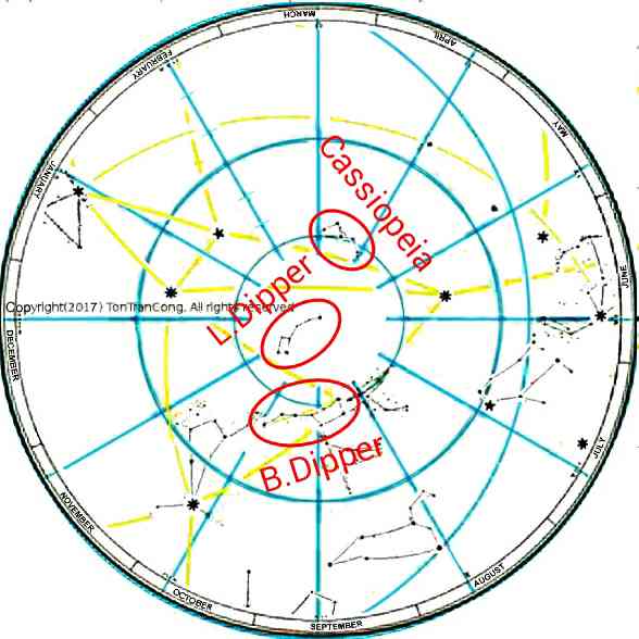
Identifying Northern polar stars
A dipper is a liquid transfer tool made of an open cylindrical container (a tubular container, a cup) with a long, nearly vertical handle and is used to take liquids out of their deep, long necked jars. An ordinary spoon or ladle would not be able to take liquids out of such long necked jars as the steep exit angle would spill the liquids back. Each of the dippers outlined by the stars here has a deep container (a cup) with opening diameter equal to only half its depth.
The Big and Little Dipper groups of stars look like a pair of such dippers. The top halves of their handles are nearly parallel and point in opposite direction while their containers open outwardly away from each other, in directions 120 degrees apart (The handle of the Little Dipper curves backward by 60 degrees). Each Dipper has seven stars, four close stars at the vertices of a quadrilateral, or quadrangle, outlining the deep liquid container and three stars outlining the long vertical handle.
The Big Dipper has a total length of 30 degrees, standing upright (deep container standing upright) in May, with the North Celestial pole at 30 degrees distance on its right (East). It is easy to spot as it has all 7 brightest stars (3 bright and 4 half-bright) in its circular neighbourhood of 35 degrees radius. The two bottom stars of the Big Dipper furthest from the tip of its handle are also called the Pointers. They point along the bottom towards Polaris on the other side of the handle line. Polaris is at a 30 degrees past the handle line.
The Little Dipper has a total length of 20 degrees. The handle of the Little Dipper curves away from the axis of the container by 60 degrees. The Little Dipper does not stand out in the sky as it has only 3 half-bright stars and 4 dim stars. One half-bright star (Polaris) is at the end of the curved handle, the other 2 half-bright stars are at the bottom of the container. The half-bright star Polaris is nearly right on the Northern Celestial pole.
(The word “dipper” is hard pressed to have Little Dipper outlining a sauce pan shaped dipper.)
The Little and Big Dippers are also known as Little and Big Bears. In this visualization, each same group of 7 stars is the outline of the upwardly curving tail (3 stars in line) and the hind part (4 close stars) of a bear.
The front (anterior) part of each Bear is well camouflaged and requires over-imagination to see. The word Dipper may be easier for description.
At mid-nights in March the Big Dipper lies horizontally with the handle below the container and parallel to the horizon. The Celestial North pole is 30 degree below its two Pointers. Alternative visualizations are: 1. A Plough in upright position, pointing to the East. 2. An upside down sauce pan (sauce pan shaped dipper). 3. The hind part and the tail of a Big Bear.
At mid-nights in June the Big Dipper rotates to its upright position with a vertical handle on the right of the container. The Celestial North pole is to its right at a 30 degrees distance (on a great circle). The Little Dipper stands on the tip of its handle (Polaris) with its container 60 degrees past the upside down direction.
Little Dipper (Little Bear) with Polaris is useful to people in Northern temperate zone since its high elevation to them (greater than 23 degrees) makes it visible. However, only the Big Dipper (the Plough/ Big Bear) is useful to equatorial people in the six months centered on March.
6. Positively identifying Northern stars.

Figure 1: Bootes Arcturus and the Summer Triangle formed by Vega, Deneb and Altair. The star map is from the Inversion map for Northern Celestial hemisphere, aligned for May 21st .

Figure 2: Mid-point of Bootes Arcturus and Vega at the center of a hemi-spherical sky view.
The features for uniquely identifying the main stars are described below.
Sirius and Vega are brightest stars in the sky. As the RA of Sirius (brightest star) and Vega (2nd brightest) differs by 12 hrs, they can never be seen together therefore cannot be distinguished only by their relative brightness. They are identified mainly based on their distances to their identifiable neighbors.
Bootes Arcturus and Vega are two brightest stars in the Northern Celestial hemisphere and both are brighter than any other star within 150 degrees distance from both of them. The great arc from Bootes Arcturus to Vega is 55 degrees long, attains highest elevation around May 23rd and is 60 degrees anti-clockwise from the intersecting constant RA arc pointing North. Bootes Arcturus leads and has only one less bright star Spica close to it (within 35 degrees distance). Vega follows and has two less bright stars Deneb and Altair close to it (within 35degrees distance).
The line Bootes Arcturus-Vega turn right by 30 degrees at Vega and continue as the line Vega-Deneb. Deneb is the next brightest star within 25 degrees from Vega. Besides Deneb, Altair is the next brightest star within 45 degrees from Vega. The line Vega-Altair is 70 degrees in the anti-clockwise direction from the line Vega-Deneb.
The triplet of the last three forms a triangle of bright stars (Vega(0.03), 25 degrees distance, Deneb(1.25), 32 degrees, Altair(0.77), 35 degrees, Vega(0.03), in anticlockwise order) known as the Summer Triangle. The vertices (accompanied by apparent magnitudes in brackets) are cited with their distances between them.
Only this triplet of three stars (Vega, Deneb and Altair) can satisfy the above descriptions and it is unique.
Arcturus alpha in Bootes (19 degrees, 14 hr), Vega (39deg,18hr36m), Deneb (45deg, 20hr41m) and Altair (9 degrees, 19.8 hr) have been identified.
Vega is closer to the Northern Celestial pole than to the Southern. If its trajectory is more than a half circle it travels anticlockwise around the upper, Northern Celestial pole, if less than, it travels anticlockwise around the now lower, below horizon, Northern Celestial pole. It reaches its highest elevation at midnight of July 1st, Vega helps identifying stars in the sky.
The distant vertex Altair of the short based Summer Triangle points away from the Northern Celestial pole.
Besides Altair, Polaris is the next brightest star within 50 degrees from both Vega and Deneb and on the other side of the line Vega-Deneb. The line Vega-Polaris is 50 degrees long and is 75 degrees in the clockwise direction from the line Vega-Deneb.
Polaris (90 degrees, any RA) has thus been identified. Its identity should be verified by using an aiming line over the tips of two sticks planted in the ground. Polaris should be seen stationary on any such aiming line.
As Polaris is almost the reflection of Altair across the short base Vega-Deneb of the isosceles Summer Triangle , the three vertices and Polaris make the vertices of a rhombus. In the counter-clockwise direction they are respectively Vega, Polaris, Deneb and Altair. This rhombus of these 4 stars is also called Weaver Shuttle by some navigators.
7. THE SOUTHERN HEMI-SPHERE

Figure: Sky map of the Southern Celestial hemisphere (Inversion map, this map shows only 20 brightest stars of the sky)The small circle on the top half, on the 24hr RA, of this map is of the same size as a great circle of the Celestial Sphere used in this Inversion projection. The circular arcs or circles centered on the 18hr RA radius are the images of some inclined great circles on the Celestial sphere.

Figure: Sky map (Inversion type) of the Southern Celestial 3/4-sphere showing only 20 brightest stars and some constellations.
Identifying Southern polar stars
The Southern Celestial pole has no noticeable bright star. Near to it (or not so near, at 30 degrees distance!) there are two bright Pointer stars (Rigil Kent, or alpha Centauri, is the trailing but very bright star and Agena, or beta Centauri, is the leading but less bright star, leading by a 5 degrees distance). Both are on the circle of 60 degrees of declination. Near to the opposite side of this circle there is also another bright star Achernar.
The Pointer stars point (into the leading direction, from a-Cen to b-Cen) at the top of a Southern Cross group of stars (group of 3 not as bright and 1 half-bright stars forming the 4 extreme points of a Christian cross, with the half-bright star at the extremity in the leading direction). The shaft length of this Cross is about 6 degrees, cross bar length 4 degrees.
During mid-nights of March the Southern Cross is upright and high in the Southern sky with two brighter Pointers trailing it on its East. Even people in the Northern tropical zone may see this upright Cross in March on their Southern horizon. However only people living well in the South, at latitude of more than 30 degrees South, can see these stars all year round. The Cross may hide under the horizon, be yearly invisible and unusable to people in tropical zone for a long period around September.
The Southern Celestial pole is of equal distances (of about 30 degrees) to the two Pointer stars and the cross-bar of the Cross. The Southern Celestial pole is thus about 4 and 1/2 extended length of the shaft below the bottom of the Cross.
Before the Pointers go lower than the Celestial pole, they point vertically downwards with the Celestial pole 30 degrees on their left. On the other side of the pole, at the same distance of 30 degrees there is a nearly as bright star Achernar (meaning “the end of the river”).
The line of alpha Centauri-Achernar is 63 degrees long and is 105 (180-75) degrees in the clockwise direction from the Pointers’ direction. Achernar is the brightest star in the disk of 30 degrees radius centered on it. Achernar can be unambiguously identified and it is still in the sky for another 11hr after a-Centauri goes lower than the Southern Celestial pole.
Achernar (meaning “the end of the river”, also named alpha Eri, 01h 37mRA, 57° degrees South , 0.46 apparent magnitude) has been identified.
The mid-point of aCen-Achernar is close to Southern Celestial pole. Rotation of this line by 10degree counter-clockwise around aCen or clockwise around Achernar places the mid-point on the Southern Celestial pole.
The line of Achernar-Southern Celestial pole is 33 degrees long and is 90 (180-90) degrees in the clockwise direction from the Achernar-Altair direction.
8. Positively identifying Southern stars.

Figure: Sirius and 4 surrounding stars (in anti-clockwise order) Canopus, Orion Rigel, Betelgeuse and Procyon.
Sirius is the brightest star in the sky. Sirius is closer to the Southern Celestial pole than to the Northern. If its trajectory is more than a half circle it travels clockwise around the upper Southern Celestial pole, if less than, it travels clockwise around the now lower, below horizon, Southern Celestial pole. It reaches its highest elevation at mid-nights of Jan 1st , Sirius helps identifying stars in the sky.
Sirius (-16 deg, 7 hr) has been identified.
As the RA of Sirius (brightest star) and Vega (2nd brightest) differs by 12 hrs, they can never be seen together for direct brightness comparison.
Canopus Alpha is the second brightest star after Sirius within 90 degrees from Sirius. Canopus is the third brightest star in the sky after Sirius and Vega. The line Sirius-Canopa is 37 degrees long .
Canopa (-53deg, 6.4hr) has been identified.
Orion Rigel is the brightest star within 30 degrees from Sirius. The line Sirius-Orion Rigel is 30 degrees long and 115 degree in the anticlockwise direction from the line Sirius-Canopa. There is a slightly dimmer Canis minor (5 degree,7.5 hr) near to Sirius; the line Sirius-Canis minor is 32 degrees long and is 225 degrees anticlockwise from Sirius-Canopus)
Orion Rigel (-8deg, 5.2hr) has been identified.
Only the triplet of three stars (Sirius, Canopa and Orion Rigel) can satisfy the above descriptions and it is unique.The triplet forms a triangle (Sirius, 37 deg, Canopa, 50 deg, Orion Rigel, 30 deg, Sirius). The vertices are cited in the anti-clockwise direction, begining and ending with the brightest star. The triplet makes a flattened nearly isosceles triangle.
Doubling the length of Sirius-Canopa and rotate it clockwise by 3 degrees gives the line Sirius-Southern Celestial pole.
The line Sirius-Southern Celestial pole is 74 degrees long and 3 degrees from in the clockwise direction from the line Sirius-Canopus and 103 degrees in the clockwise direction from the line Sirius-Orion Rigel.
From Sirius and Canopus, it is easy to identify the Pointer Stars (alpha and beta Centauri) near the Southern Celestial pole. The line Sirius-alpha Centauri(Rigil Kent) is 90 degrees long and 20 degrees in the clockwise direction from Sirius-Canopus while Sirius-beta Centauri(Agena) is 87 degrees and 22 degrees.
Both of alpha Centauri (Rigil Kent ) and beta Centauri (Agena, dimmer and leading it by 4.5 degree distance) are on the 60 degrees South declination circle. Their difference in RA is 36 minutes and their angular distance on the Celestial sphere is nearly 4.5 degrees (= 2arcsin(2cos60sin(8.97/2)) =4.481deg.). This is about 4 finger widths or nearly the width of a closed fist on a stretched arm.
They are two bright stars near the Southern Celestial pole and point to the Southern Cross group of stars. Extending the pointer line alpha-beta Centauri (Rigil Kent-Agena) to 17 degrees (to 3.5 times its original length) from alpha Centauri (Rigil Kent) reaches the top star of Southern Cross (group of 3 bright and 1 dim stars forming the 4 extreme points of a Christian cross, with a shaft length of 6 degrees, cross bar length of about 4 degrees) . The Southern Celestial pole is of equal distances (of about 30 degrees) to the two Pointer Stars and the intersection of the Cross. It is 90 degrees in the clockwise direction from the Pointers’ direction. The Southern Celestial pole is thus about 4 and 1/2 extended length of the shaft below the bottom of the Cross.
During the nights of March the Southern Cross is upright and high in the Southern sky and its two bright Pointer stars are on its left (trailing side).
The Southern Celestial pole should be verified by checking that all stars move on circles centered on it.
The line alpha Centauri (Rigil Kent)-Canopus is 50 degrees long and is 40 degrees in the clockwise direction from the pointer direction alpha-beta Centauri (Rigel Kent-Agena) .The line alpha Centauri (Rigel Kent)-Sirius is 85 degrees long and is 20 degrees in the clockwise direction from the pointer direction alpha-beta Centauri (Rigel Kent-Agena) .
The line alpha Centauri (Rigil Kent)-Altair is 95 degrees long and is 172 degrees in the counter-clockwise direction from the pointer direction alpha-beta Centauri (Rigel Kent-Agena). Within 30 degrees distance from it, Altair is the brightest star. It is thus easy to identify the tropical Altair using the Southern Cross Pointer Stars in order to use it before the Pointers hide themselves under the Southern horizon.
9. USEFUL BRIGHT STARS

Figure 1: List of 20 brightest stars.

Figure 2: A real dipper and insets for Big Dipper and Little Dipper.
So people have to use a number of different identifiable stars for navigation. The star maps (or star charts) help them find suitable stars. For me, the easy to use bright stars are:STAR or CONSTN Decl(deg) RA (hr), Sun RA, Time fr EQUIN MIdnight high on
Polaris Const 90 15, ==> 3, 3×0.5=1.5month Mar21+1.5m=May10th
SCross Const -60 12, ==> 0, 0x0.5=0month Mar21
Rigel Kent (alpha Centauri), (-61deg, 7.7 hr)
Agena (the knee, Hadar, beta Centauri) (-61 deg, 7 hr)
Vega star 39deg 18hr36m, July 1st (from table)
Deneb star 45deg 20hr41m
Altair 9 19.8, ==> 7.8×0.5=3.9month Mar21+3.9month Jul 18th or Jul 20th (from table)
Boote brgt star 19 14, Apr 25th (from table)
Sirius brtest star -16 7, Jan 1st (from table)
Canopus (-53deg, 6.4hr)
Orion Rigel (-8deg, 5.2hr), Dec 19th (from table)
Orion belt star 0 5.5 17.5 17.5×0.5=9month Mar21+9m=Dec21st
10. Notes on identifying stars.

Figure 1: Mercator sky-map, for upside down reading, of brightest stars and great circle arcs to their neighbours.
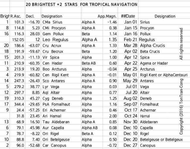
Figure 2: Table of 20 brightest +2 stars in order of appearance.
The term “distant vertex” of a triangle denotes the vertex facing the shortest side of that triangle.
The stars (objects outside the Solar system) to be used as the reference marks on the sky are Polaris (a bright star nearly right on the Celestial North pole), Vega (the second brightest star in the sky, 39 degrees from Polaris, with RA of 18hr36m), Sirius (the brightest star in the sky, 106 degrees from Polaris, 74 degrees from the Southern Celestial pole, RA of 7hr.).
Starting from Polaris and Vega it is unambiguous to identify Deneb and Altair while starting from Polaris, Vega and Sirius it is unambiguous to identify Orion group of stars.
These stars can then be used to identify any other stars in the sky.
Polaris (for finding North and latitude) is the brightest star of the constellation Little Bear (alternatively called Little Dipper). The Little Dipper stand inverted on its handle at midnights of May.
Southern Cross Constellation and its two brighter, trailing Pointer Stars (beta Centauri and then the brighter alpha Centauri, on a straight line with the center of the Cross) are all at 30 degrees distance from Southern Celestial pole in the sky. The Southern Cross constellation becomes an upright Christian cross planted above Southern Celestial pole at midnights of March.
Southern Cross and its two Pointer stars are always visible to navigators in Southern temperate zone.
Around September 23rd, Southern Cross and its two trailing Pointers are lowest in the sky and navigators in the Southern tropical zone cannot see them. However, they can instead use Achernar (opposite the Pointers across the Southern Celestial pole) or either of or both of the setting, bright tropical star Altair (9deg, 19hr50) and the rising, bright tropical star Orion Rigel (-8deg, 5.2hr) for navigation. At least one of these two are 12 degrees above the horizon at that time. Bright, late rising mid-declination Canopus (-53deg, 6.4hr) may also be used.
Vega (of July 1st) and Bootes Arcturus (of April 25th) are two brightest stars in the Northern Celestial hemisphere, being 55 degrees apart in the sky and both are brighter than any other star within 150 degrees distance from both of them. Vega has two bright stars Deneb and Altair close to it (within 35degrees distance) whereas Bootes Arcturus has only one bright star Spica close to it (within 35degrees distance). Therefore within a 55 degrees distance around Vega, one of the two brightest stars in the Northern hemisphere, the three other brightest stars are Bootes, Deneb and Altair. They surround Vega and form a slender anti-clockwise triangle with Bootes being the distant vertex and Vega being near to its center of gravity.
Within the distance of 35 degrees around Bootes there is a uniquely identifiable bright star on the other side of the Celestial equator, that is Spica (-11.1deg decl., 201.3deg 7hr25 RA or April 12th). The line Bootes to Spica is at 30 degrees counter-clockwise from line Bootes to Southern Celestial pole.
Within 25 degrees distance around Vega, the next brightest star is Deneb (45 deg, 20 hr 41 m), a star 70 degrees on the trailing side of its Celestial North. Within the second larger distance of 35 degrees around Vega there is another uniquely identifiable bright star, which is Altair, at 40 degrees on the trailing side of its Celestial South.
Altair(9 deg, 19hr 50)’s name has foreign origins (Al Nesr Al Tair, in Arabic; Vultur volan, in Latin). People in the tropic can use Altair around July 20th and Sirius (brightest star) around Jan 1st for identifying neighbouring stars and for navigation. Altair and Sirius stars are 13 hr apart in R.A. so at least one of them will be visible in any tropical or temperate sky except for 1 hr in any continuous 24 hr hours period.
The small, short based, nearly isosceles , anti-clockwise triangle formed by Deneb, Altair and Vega is known as the Summer triangle in the Celestial sphere with its pointed, distant vertex Altair pointing away from the Northern Celestial pole.
As Polaris is almost the reflection of Altair across the short base Vega-Deneb of the isosceles Summer Triangle, the three vertices of this triangle and Polaris make four vertices of a rhombus. The vertices are respectively Vega, Polaris, Deneb and Altair in the counter-clockwise direction . The stars here are Vega and its 3 brightest nearby stars within a distance of 65 degrees. The diagonals of this rhombus have sizes of 81 degrees (Polaris to Altair, along the Celestial North South arc) and 21 degrees (Vega to Deneb, leading to trailing directions). This rhombus of these 4 stars is also called Weaver Shuttle by some navigators from Northern hemisphere.
Sirius (meaning glowing, scorching; at -16 degrees, 7 hr), is the brightest star, or more accurately binary star system, in the sky. It is in the Dog group of stars near to the trailing foot of Orion. It is a useful star for identifying its neighbours. People in the tropic can use Altair around July 20th or Orion-Rigel around Dec 10th or Vega (very bright star in the North) around July 1st or Sirius (the brightest in the South) around Jan 1st and for identifying neighbouring stars.
Sirius simplifies the identification of its 4 neighbours which are in the top 10 brightest stars. Sirius is at the center of a broom head, surrounded by 4 neighbours outlining the extremities of the broom. Canopa is the second brightest star and is at the end of the broom handle. The angled line (Orion-Rigel, 18 degrees distance, Betelgeuse, 25 degrees distance, Procyon) outlines the extremity of the broom head. The vertices are 3 bright stars on a 100 degree counter-clockwise circular arc of 25 degree radius, centered on the brightest star Sirius. The bisector of the 60 degrees anti-clockwise angle (Betelgeuse, Sirius, Procyon) points to the North Celestial pole while Sirius-Canopa points in its opposite direction, at the Southern Celestial pole.The trailing half of the broom head is an equilateral triangle (Sirius, Betelgeuse, 26 degrees distance, Procyon, Sirius, in counter-clockwise order). Its center of gravity is less than 2 degrees South of the Celestial equator and its base Betelgeuse-Procyon is a constant declination arc.
Orion’s central belt star (0 degree, 5.5hr) is right on the Celestial equator. It readily gives the accurate North direction by my method [1]. It is a star of December. However it is not the brightest star in the Orion group. The brightest star of Orion is Rigel, at Orion’s leading (Westward) foot and the second brightest is Betelgeuse, at Orion’s trailing (Eastward) shoulder; all other stars of Orion are much dimmer. The line joining these two brightest stars of Orion is about 25 degrees long and forms with the line of 3 regularly spaced (much dimmer) belt stars of Orion the distinctive shape of two diagonals of a slender rhombus. The line of the 3 belt stars has 1/6 the length of and is at right angle to the line Rigel-Betelgeuse; its extension also goes through Sirius. The line Rigel-Betelgeuse is oriented 30 degree anticlockwise from its North pointing RA semi-circle. The two shoulder stars of Orion are almost right along the Leading-Trailing direction. The dagger stars of Orion are right along the RA semicircle.
Procyon is right behind Orion group of stars and is a mid-January equatorial star. The next bright equatorial stars are Spica and Bootes Arcturus, they are behind Procyon by 6 hours.
Before losing the two Southern Pointer stars to their ever earlier setting time, navigators in Southern tropical zone can easily identify the bright tropical star Altair to replace these Pointers. The line of alpha Centauri-Altair (Rigel Kent, brighter Pointer-Altair) is 95 degrees long and is 170 degrees in the counter-clockwise direction from the direction brighter to dimmer pointers (alpha Centauri, Rigel Kent-beta Centauri, Agena). Within 30 degrees distance from it, Altair is the brightest star. Altair can be unambiguously identified and it is high in the sky.
Before Altair (9 deg, 19.8 hr) sets nearly at 279 (=270+9) degrees in the West there is already Orion Rigel (-8 deg, 5.2 hr) rising at nearly 98 (90+8) degrees in the East (The two stars are almost setting and rising at opposite directions.). This Orion Rigel is only 24 hr +5.2hr -19.8hr = 9.4hr = 141 degrees RA behind Altair. So at least one in this pair (Altair, Orion Rigel) are above 12 degrees (=0.5*(180 – 141)* cos 30) in elevation to tropical navigators to be used as navigational stars.
When the Big Dipper is standing upright (with the dimmer Little Dipper standing on the tip of its handle and its container 60 degrees past the upside down direction) the Summer Triangle (Vega, 25 deg, Deneb, 32 deg, Altair, 35 deg, Vega) is already well above the horizon. When the two Pointers go below the Northern Celestial pole the Summer Triangle can be used to find North.
The line Deneb – Celestial pole is 45 degrees long and is 90 (=180-90) degrees in the counter-clockwise direction from the line Deneb – Vega.
The line Deneb – Capella is 80 degrees long and is 120 (=180-60) degrees in the counter-clockwise direction from the line Deneb – Vega. Rotation of this line by 30 degree or clockwise around Deneb or counter-clockwise around Capella places the mid-point on the Southern Celestial pole. This pole is of equal 45 degrees distances from both stars.
Before Vega goes lower than the Northern Celestial pole, the Orion constellation has risen in the Eastern direction. This constellation has two bright stars Orion-Rigel and Betelgeuse. The line joining these two is the short diagonal of a 3-to-1 rhombus (Sirius, Orion-Rigel, Aldebaran, Betelgeuse, Sirius, in counter-clockwise direction).
The tropical September mid-nights have no bright star near to the zenith. Navigators have to use bright stars on the West (including the pair Fomalhaut-Deneb) early in the night and then switch to bright stars on the East late in the night. Fomalhaut, 30degrees South declination, is a September star. Fomalhaut and Deneb are separated by about 75 degrees distance, straddling the Celestial equator. The North and South Celestial poles are respectively 90+30 and 90-30 degrees from Fomalhaut.
11. USING A POLAR MAP OF STARS

Figure: Using a star map on the 21st of July, the selected date is on the rim.
Select the current date in the year on the rim of the polar map. The Sun should be located at a point on the ecliptic nearest to this date on the rim. The Sun should be on the radial (meridional) line connecting the date on the rim to the Celestial pole at the center of the map. Verify that the intersection of this radial Right Ascension line and the ecliptic gives a position of the Sun corresponding to the season in the year (for example, around March, the Sun travels on the ecliptic, crossing the Celestial equator, to come to the Northern hemisphere from the Southern hemisphere; Northern Spring equinox occurs on 21st March).
Align the center of the circular map to the corresponding Celestial pole by first aligning its axis to the terrestrial North or South (a magnetic compass is good enough this job!) then raise it to the higher Celestial pole by an angle equal to the latitude value of your place.
Align the map so that the Sun on the map be on the bottom radius (or Right Ascension) line. The line of Right Ascension 12 hr from it is the meridional line for midnight of that day. Stars on this RA line should attain their highest elevations at midnight.
Stars on the RA few hours before or after that will ascend few hours before or after midnight.
The actual stars will be in the radial direction of the stars displayed on the circular map.
A night navigator will select identifiable stars whose declinations are nearly equal to his latitude. They will pass by his zenith. Stars distant from his zenith may not be visible due to terrestrial obstructions. (For example, the Polaris star may not be visible to many people in tropical zone since it is too close to the horizon line which often has obstructions) .Therefore a navigator in non-polar regions has to choose bright stars with various RA but with declination values close to his latitude so that at any time there is at least one of them being close to the zenith and these stars are used cyclically through different times for continuous navigation.
12. FINDING NORTH AND TIME USING THE DECLINATION OF A STAR AND LATITUDE

Figure: Finding North direction and time by any star is similar to that by the Sun but with the STAR INSTEAD of the Sun.
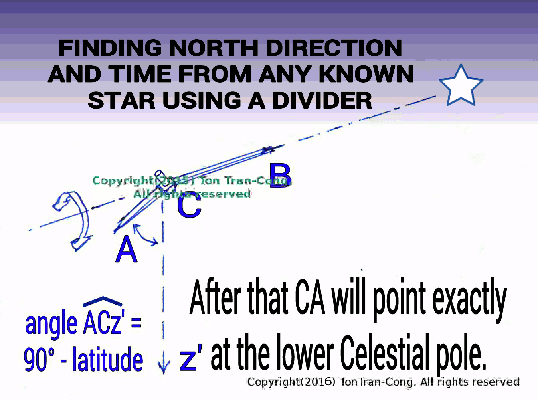
Figure: Finding North and time by any bright star.
1a/- Once a star is identified, its constant declination is obtained, the Instructables “Finding North direction and time from the Sun using bare hands” [1] can be applied but with the star instead of the Sun. The time from the method is with respect to the star.
When a star is used on its date in the year, the Sun leads it by exactly 12 hours. For every month after that, the lead by the Sun is reduced by 2 hours.
1b/- When the date of the star is not readily available, its RA can be used instead.
Lead on time by the Sun = Solar Time – Time Relative to star = RA star – RA sun.
The difference star RA – solar RA must be ADDED to it to give local time with respect to the Sun (a star with larger RA will rise later than a star with smaller RA).
Example:
Sirius is a star of Jan 1st. On Jan 1st the time determined by Sirius is 12 hours behind the time by the Sun. On April 1st, the time determined by Sirius is 6 (=12-3*2) hours behind the time by the Sun.
2- Alternatively, the shapes of identifiable constellations can tell how the Celestial sphere is orientated, and this may easily give information on both direction and time to people who watch the Celestial sphere nightly and have learned it by heart (Traditional sea fishermen in Vietnam have such memory for positions at various times for bright equatorial stars/constellations in the Celestial sphere).
References
[1]. tonytran2015, Finding North direction and time using the Sun and a divider, http://www.survivaltricks.wordpress.com/, 06 May 2015.
[2]. tonytran2015, Finding North direction and time using the hidden Sun via the Moon,https://survivaltricks.wordpress.com/2015/07/06/finding-north-direction-and-time-using-the-hidden-sun-via-the-moon/, posted on July 6, 2015
[3]. tonytran2015, Finding North direction and time accurately from the horn line of the Moon. https://survivaltricks.wordpress.com/category/moon-horn-line/
posted on August 12, 2015
[4]. tonytran2015, Finding North direction and time using the Moon surface features , https://survivaltricks.wordpress.com/2015/07/01/finding-north-direction-and-time-using-the-moon-surface-features/ , posted on July 1st, 2015
RELATED SURVIVAL blogs
Navigating with an AM MW radio receiver, posted January 17, 2017, The Scorpius constellation, posted January 8, 2017, The Orion constellation., posted December 26, 2016, Rice as emergency food., Using GPS in off-grid situations, Slide Sky-Disks with grid masks showing azimuths and altitudes, Slide Sky-Map for displaying tropical stars.
, posted on 2018 July 10

Finding-north-by-stars-for-beginners, posted on September 20, 2017

Finding North and time with unclear sky. Posted on October 17, 2015.


Finding North direction and time by any bright star, posted July 22, 2016

Slide Sky-Disks with grid masks showing azimuths and altitudes, posted November 3, 2016

Slide Sky-Map for displaying tropical stars, posted on October 7, 2016

Click here for my other blogs on  SURVIVAL
![]()
SURVIVAL CONTENTS BLOG IMAGE OF SURVIVAL CONTENTS
![]()
MONEY CONTENTS BLOG IMAGE OF MONEY CONTENTS
![]()
SOCIAL ISSUES CONTENTS BLOG IMAGE OF CONT. OF SOCIAL ISSUES
LIVING BLOG LIVING CONTENTS BLOG IMAGE OF LIVING CONTENTS
HOW TO BLOG HOW TO CONTENTS BLOG IMAGE OF HOW TO CONTENTS
Click here go to  Home Page (Navigation-Survival-How To-Money).
ARCHIVAL HOME PAGE CONTENTS HOME PAGE BLOG IMAGE OF CONTENTS HOME PAGE

You’re so cool! I do not think I’ve read through anything like this before. So great to find somebody with some genuine thoughts on this issue. Really.. thank you for starting this up. This website is one thing that is required on the internet, someone with some originality!|
LikeLike
I’m truly enjoying the design and layout of your site. It’s a very easy on the eyes which makes it much more enjoyable for me to come here and visit more often. Did you hire out a designer to create your theme? Outstanding work!|
LikeLike
It’s actually a great and useful piece of information. I’m glad that you simply shared this useful info with us. Please stay us informed like this. Thanks for sharing.|
LikeLike
This site certainly has all of the information and facts I needed concerning this subject and didn’t know who to ask. |
LikeLike
Amazing Site
LikeLike
An impressive share! I’ve just forwarded this onto a friend who had been doing a little research on this. And he actually ordered me breakfast due to the fact that I stumbled upon it for him… lol. So let me reword this…. Thanks for the meal!! But yeah, thanks for spending the time to talk about this topic here on your website.|
LikeLike
Since the admin of this site is working, no doubt very quickly it will be renowned, due to its quality contents.|
LikeLike
Wow, amazing weblog structure! How long have you ever been blogging for? you made blogging look easy. The full look of your web site is wonderful, let alone the content material!
LikeLike
What’s up to all, it’s actually a nice for me to visit this website, it consists of valuable Information.|
LikeLike
Ahaa, its fastidious discussion regarding this paragraph here at this blog, I have read all that, so now me also commenting at this place.|
LikeLike
Hello, all the time i used to check weblog posts here in the early hours in the morning,
because i like to gain knowledge of more and more.
LikeLike
I see you don’t monetize your website. You can earn extra passive income, your
niche is good for one method, just search in google – website monetization methods
by Riggso
LikeLike
Thank you, Raymond81, for the suggestion.
My desire is to have many others sharing the knowledge on my site. Currently keepping this site is not too costly and I don’t need financial support from my readers yet.
LikeLike