

Finding North in the polar zones using Equatorial Stars and the Sun
by tonytran2015 (Melbourne, Australia).
Click here for a full, up to date ORIGINAL ARTICLE and to help fighting the stealing of readers’ traffic.
(Blog No.66).
#find North, #finding North, #polar zone, #arctic zone, #Equatorial stars, #Sun, #Viking, #navigation .
Finding North in polar regions using Equatorial Stars and the Sun.
The general principles in Finding North still apply for each familiar method. However Finding North direction in polar regions has its own problems and it is not as simple as for temperate zones due to difficulties caused by steep magnetic lines not pointing to rotational poles, by the closeness of the upper Celestial pole to the zenith, by long extended day time, by aurora light, by aurora interference with radio wave receivers in GPS units.
When those familiar methods encounter problems the method of Finding North by Tropical stars and the Sun can still work and maintain its precision. The Viking may had used this technique in their long sea voyages many centuries ago.
1. The two polar zones
The two polar zones cover any area with absolute value of latitude higher than 66°33′. That is all their points are less than 23°27′ from one of the two poles. The Northern polar (arctic) zone covers parts of Greenland, Iceland, Sweden, Norway, Finland, Russia, U.S. Alaska, Canada with many of their cities. The Southern polar (antarctic) zone covers parts of Antarctica continent (with Argentinian stations, UK Rother station, etc …).
The ratio of the lengths of Day versus Night varies with a yearly cycle on any point of the Earth. In Arctic zone, it reaches 0-100 for some period centered on Winter solstice (on 21 December ) when the Solar path is totally below the horizon. The ratio then varies from 1-99 to 99-1. It then reaches 100-0 for some other period centered on Summer solstice (on 21 June ) when the Solar path is totally above the horizon. The ratio then varies from 99-1 to 1-99 and reaches 0-100 again.
It is similar for Antarctic zone except for the 6 months time difference between the two polar zones.
2. Finding North by GPS.

Figure: A GPS screen.
The easiest way to find North in a polar region is to use the GPS apps on smart phones or on purpose made GPS units.
GPS compass directions are calculated from the change in terrestrial coordinates when you move. The minimum movement distance is only about 5m.
GPS compass directions are true directions and are different from and independent of magnetic compass directions.
However, GPS units may run out of battery, be non-operational during war times, be under heavy interference from polar aurora storms. A non-GPS back up method is still necessary.
3. Finding North by a magnetic compass.

Figure: A magnetic compass.
3a. The magnetic poles are not exactly at the North and South poles of the Earth. They are currently in Canada and near to New Zealand respectively. Users of magnetic compasses should know how to compensate for this.
3b. Magnetic lines are also nearly vertically inclined in polar regions making normal compasses sticky with their needles and they may have to be replaced by cruder magnetic rods hung on wire threaded through holes near to their mid-points.
3c. Aurora in the sky changes very slowly and can be used as overhead navigational marks juat like permanent clouds.
4. Finding North using Polaris.

Figure: The Northern and Southern Polar skymaps are represented by two circular discs here.

Figure: Photo of a real dipper. Inset: The Big Dipper and Little Dipper constellations.
4a. Polaris in the Little Dipper is right on the North Celestial pole. The North Celestial pole is in the Northern direction of all vertical plumb lines. If the star can be obscured by any plumb line then you eye is exactly on the South of the line. Near to the pole, Polaris is close to the upper extension of any vertical plumb line and it is hard to obscure it by some vertical plumb line.
4b. The altitude of Polaris is most easily read with a Bubble Sextant (Aircraft Sextant) or with a Theodelite (for higher accuracy). The direction with smallest value of altitude of Polaris is Northern direction.
The method is easily applicable at night time but Polaris cannot be seen during day time and during aurora storms.
5. Basis of finding North by Tropical stars.
 Figure: Panoramic view of the Celestial Equator and the Tropical band from the Arctic zone in December. Stars travel from Front Left to Front Right. The directions and Solar times corresponding to the scale on the bottom of the picture are N(0hr)-E(06hr)-S(12hr)-W(18hr)-N(24hr).
5a. Any point on the Earth sees exactly half of the Celestial Equator above its horizon. The angle between the plane of this half circle and the horizontal one is equal to (90°- latitude).
The Celestial Equator is inclined to the ground and is below the horizon in the North direction in the Northern hemisphere.
5b. Equatorial stars such as the Central Belt Star of the Orion travel along this circle once every day. They rise and set exactly in the exact East and exact West directions respectively.
 Figure: Panoramic view of the Celestial Equator and the Tropical band from the Antarctic zone in June. Stars travel from Front Right to Front Left. The directions and Solar times corresponding to the scale on the bottom of the picture are S(24hr)-W(18hr)-N(12hr)-E(06hr)-S(0hr).
5c. Any tropical star (any star which is no further than 23°27′ from the Celestial Equator) travels along one large (but not great) circle in the sky every day. The circle is “parallel” to the Celestial Equator.
5d. The elevation/altitude of the star varies daily with an amplitude equal to (90°-observer’s latitude) about its daily mean (which is nearly equal to its Declination multiplied by the sine of observer’s latitude)
5e. The North Souih line is the bisector of two directions pointing to any two positions having equal elevations of the same star. The common elevation can be conveniently chosen to be the mean of its 24hr values.
6. Solar trajectory on the Celestial Sphere
The Sun travels along one large (but not great) circle in the sky every day. The circle is “parallel” to the Celestial Equator. The circular Solar path drifts to its most Northern position at 23°27′ latitude on 21 June solstice then drifts to its most Southern position at 23°27′ latitude on 21 December.
At equinox times, the Sun is exactly on the Celestial Equator and rises and sets exactly like an equatorial star.
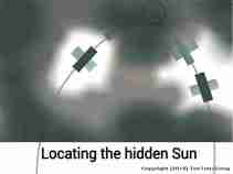
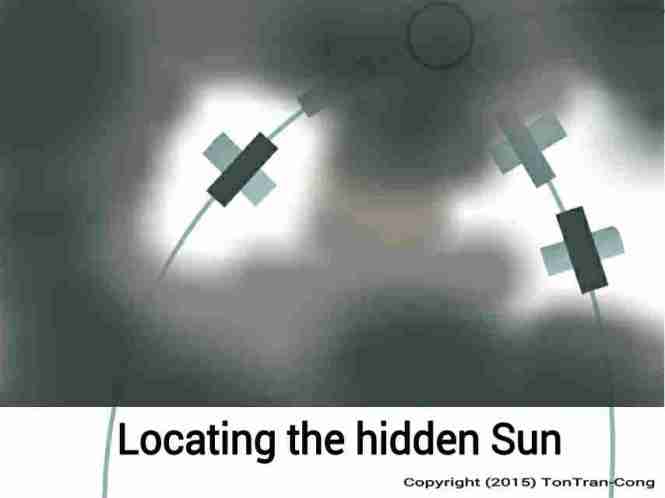 Figure: Locating the hidden Sun by polarized light from bright patches of the sky.
Knowing the trajectory of the Sun, you can locate it using polarizing sunglasses even when it is hidden and under the horizon (see ref. [5], Using polarized light to locate the Sun when it is hidden from view).
7. Measuring solar altitude with a stretched hand on an extended arm.
A hand with stretched out fingers hold on its extended arm sustains an angle of about 12 degrees and is a very convenient mean for measuring Solar elevation (altitude) angle in polar regions.
8. Variation of Solar altitude/elevation during the day.
Solar elevation/altitude varies daily with an amplitude equal to (90-latitude) about its daily mean (which is nearly equal to Solar Declination of the day multiplied by sine of local latitude).
You can tell where is the Sun on its daily cycle by measuring its altitude with a stretched hand on an extended arm.
As the Sun travels on a known wavy line its altitude gives both its compass direction and the corresponding time of the day.
The directions and times corresponding to the scale on the bottom of the first panoramic picture (for Arctic regions) are N(0hr)-E(06hr)-S(12hr)-W(18hr)-N(24hr).
For Antarctic regions the directions and times corresponding to the scale on the bottom of the second panoramic picture are S(24hr)-W(18hr)-N(12hr)-E(06hr)-S(0hr).
9. Time estimation from Solar altitude
Solar altitude may give a better time estimation near to Sunrise and Sunset.
The time is 6hr or 18hr when the altitude of the Sun crosses its mean value.
10. Distinguishing AM from PM
When using the Sun for navigation, it is important to know whether the Sun is ascending (AM) or descending (PM).
10a.A 24hr sub-dial on a clock face is certainly useful in telling AM and PM.
10b. Ambient air temperature after receiving daylight radiation is also usually higher in PM time than in AM time.
10c. There are different sets of stars in the sky for AM and PM in the night.
10d. Birds activities are different in AM and PM.
10e. Your biological clock (circadian rhythm) may help distinguishing AM and PM.
11. Finding North with a watch in a polar region

Figures: Finding North with a watch for antarctic and arctic zones.
Finding North with a watch needs a modification: If you can travel to the nearest pole in 2hr, you have to remember that the 6-12 line on the watch points along the meridian line of your home city, not toward the Pole of the Earth. Indeed, you can travel around the pole but that 6-12 line keeps its direction along the meridian of your home city.
The watch face can be simply laid horizontally as in the original “Scout method” without generating any noticeable directional error.

Figure: A map of the arctic from National Oceanic and Atmospheric Administration (https://www.pmel.noaa.gov/rediscover/resources). All meridional lines converge at the pole.
12. Finding North with a divider in a polar region

Figure: Estimating Solar declination by drawing a watch face with a subdial.

Figure: Finding North by a divider.
The divider method is still applicable for finding direction and time but requires high accuracy in Solar declination and latitude angle for setting the divider.
A small plumb line hanging from the stem of the divider can improve the accuracy for its latitude angle setting.
With the above additional plumb line, the divider can measure the altitude of the Sun to give a good estimate of time.
13. Finding North with an AM Broadcast radio receiver in a polar region

Figure: An AM Broadcasting radio receiver wirh an internal ferrite rod antenna.
The method of finding direction using an AM radio receiver tuned to nearby broadcasting ([8]) is useful near to cities with AM broadcasts in polar regions. The transmission is not effected by low visibility from bad weather. You need a map of the region with AM transmitters as landmarks.
References.
[1]. tonytran2015, Using GPS in off-grid situations., https://survivaltricks.wordpress.com/2016/12/06/using-gps-in-off-grid-situations/, posted December 6, 2016
[2]. tonytran2015, Selecting and using magnetic compasses, survivaltricks.wordpress.com, https://survivaltricks.wordpress.com/2016/07/09/selecting-and-using-magnetic-compasses/, posted 09/7/2016.
[3]. tonytran2015, Finding North direction and time by stars, survivaltricks.wordpress.com, https://survivaltricks.wordpress.com/2015/08/28/finding-north-and-time-by-stars/ , posted on August 28, 2015.
[4]. tonytran2015, Finding North and time by stars in the tropics, survivaltricks.wordpress.com, https://survivaltricks.wordpress.com/2016/05/25/finding-north-and-time-by-stars-in-the-tropics/, posted on May 25, 2016
[5]. tonytran2015, Using polarized light to locate the Sun when it is hidden from view, https://survivaltricks.wordpress.com/2015/05/09/using-polarized-light-to-locate-the-sun-hidden-behind-clouds/, posted on May 9, 2015
[6]. tonytran2015, Finding accurate directions using a watch, survivaltricks.wordpress.com, https://survivaltricks.wordpress.com/2015/05/19/finding-accurate-directions-using-a-watch/, posted May 19, 2015
[7]. tonytran2015, Finding directions and time using the Sun and a divider, survivaltricks.wordpress.com, https://survivaltricks.wordpress.com/2015/05/06/finding-directions-and-time-using-the-sun-and-a-dividing-compass/, posted on May 6, 2015.
[8]. Navigating with an AM MW radio receiver.
[9]. https://www.pmel.noaa.gov/rediscover/resources.
RELATED SURVIVAL blogs:
Using polarized light to locate the Sun when it is hidden from view. . Posted on May 9, 2015. This is a useful technique.
Using GPS in off-grid situations., posted December 6, 2016

Adding longitude and latitude lines to a map, posted August 23, 2017

Navigating with an AM MW radio receiver, posted January 17, 2017

Latest SURVIVAL blogs:
Good approximation to solar declination by a watch face, Navigating with an AM MW radio receiver, The Scorpius constellation, Quick fire making using sunlight.,The Orion constellation, Rice as emergency food , Using GPS in off-grid situations, Identifying moderately bright navigational stars, Slide Sky-Map for displaying tropical stars,…all.
BLOG IMAGE OF SURVIVAL CONTENTS
Click here to go to  Home Page (Navigation-Survival-How To-Money).
BLOG IMAGE OF TOP LEVEL CONTENTS PAGE


